17 Awesome Palm Springs Hikes in Southern California
While thinking of Palm Springs might conjure up images of lounging around the pool and art deco flair, this desert hotspot is also an outdoor oasis. The mountains collide with the desert here, and the best Palm Springs hikes provide views of both.
From beautiful trails through oases of fan palms to epic mountain summits – and a unique aerial tram ride to a trailhead – Palm Springs offers unique adventure in the Coachella Valley of Southern California.
ABOUT THIS GUIDE TO THE BEST PALM SPRINGS HIKES
We’ve organized the list of hikes in Palm Springs by difficulty, so you can easily find a perfect hike for you! Since everyone has a slightly different gauge of what is “easy” or “difficult” hiking, here is how we’ve defined the list:
Best Easy Hikes in Palm Springs - These hikes are under 5 miles OR less than 500 feet of elevation gain.
Best Moderate Hikes in Palm Springs - These hikes are less than 9 miles with more than 500 feet of elevation gain.
Best Difficult Hikes in Palm Springs - These hikes are over 9 miles with over 2,000 feet of elevation gain.
WHEN TO VISIT PALM SPRINGS
Palm Springs sits in a desert landscape, so you want to avoid the heat of summer when hiking here. Spring is a great time to visit Palm Springs for moderate temperatures, and fall is nice, too.
But keep in mind that some of the trails here head up to higher elevation, and might still have snow on them in spring (or get snow in the fall). Be sure to check conditions before attempting hikes in the mountains around Palm Springs.
Now here are 17 of the best hikes in Palm Springs to explore this amazing area!
BEST EASY HIKES IN PALM SPRINGS
1. Andreas canton
Andreas Canyon Quick Facts:
Type of Trail: Loop
Total Mileage: 1 mile
Total Elevation Gain: 177 feet
Difficulty: Easy
Andreas Canyon is the perfect intro to hikes in Palm Springs. It’s a short, easy loop through a beautiful fan palm oasis. Andreas Canyon is part of Indian Canyons, the ancestral home of the Agua Caliente Band of Cahuilla Indians. It is a very popular area with lots of trails.
Note: There is an admission fee of $12/adult to enter Indian Canyons, which you can pay at the trailhead.
2. PALM CANYON-VICTOR LOOP
Palm Canyon-Victor Loop Quick Facts:
Type of Trail: Loop
Total Mileage: 3 miles
Total Elevation Gain: 365 feet
Difficulty: Easy
You can do another easy but slightly longer loop in Indian Canyons by combining Palm Canyon Trail with Victor Trail. Lots of palm trees line the trail, and the hike along the ridge offers excellent views.
Note: There is an admission fee of $12/adult to enter Indian Canyons, which you can pay at the trailhead.
3. SPLIT ROCK LOOP
Split Rock Loop Quick Facts:
Type of Trail: Loop
Total Mileage: 2.4 miles
Total Elevation Gain: 275 feet
Difficulty: Easy
Located in Joshua Tree National Park, this rocky loop heads through boulder fields, with plenty of Joshua Trees along the way. Pay attention to signs marking the trail because it can be somewhat difficult to follow at certain points. If you want to extend your hike, you can connect this trail with the Skull Rock Trail.
For lots more trails in Joshua Tree, check out our guide to Joshua Tree hikes!
4. TAHQUITZ CANYON LOOP
Tahquitz Canyon Loop Quick Facts:
Type of Trail: Loop
Total Mileage: 2 miles
Total Elevation Gain: 324 feet
Difficulty: Easy
Tahquitz Canyon is another part of the Agua Caliente Band of Cahuilla Indians Reservation. The loop trail takes you to Tahquitz Falls, a gorgeous 60-foot waterfall splashing down the rocks. If you want to see the water running, do this hike between October to May and avoid the hot summer.
Note: There is an admission fee of $15/adult to enter Tahquitz Canyon, which you can pay at the trailhead.
5. DESERT VIEW TRAIL
Desert View Trail Quick Facts:
Type of Trail: Loop
Total Mileage: 1.9 miles
Total Elevation Gain: 334 feet
Difficulty: Easy
For a truly unique experience, take the Palm Springs Aerial Tramway up to Mount San Jacinto State Park and do this easy hike to take in some seriously breathtaking views.
At the top of the tram, you’ll find a restaurant, bar, and gift shop, but once you step outside, you might be surprised by the wilderness that is right there. Expect plenty of company on this trail, but hiking through the forest and stopping at the scenic overlooks is a special experience.
(If you want a harder hike here, you can take the tram and then summit Mount San Jacinto, which we’ll go into more details about in the “Difficult Hikes” section below.)
Note: You must buy a timed ticket for the tramway ($35/person), which you should do ahead of time online here or at the station when you arrive. Tickets are known to sell out, so purchasing ahead of time is recommended.
GRAB MY [FREE] OUTDOOR BACKPACKER STARTER KIT
I created the Ultimate Outdoor Backpacker Starter Kit for you (and it's FREE)! This starter kit is filled with 14 pages of my best hiking and backpacking tips to help you learn what it takes to become a safe, confident, and self-sufficient outdoor backpacker!
BEST MODERATE HIKES IN PALM SPRINGS
6. ARABY TRAIL
Araby Trail Quick Facts:
Type of Trail: Out & back
Total Mileage: 3.3 miles
Total Elevation Gain: 1,380 feet
Difficulty: Moderate
The Araby Trail attracts a variety of hikers, from those looking for a steep workout to architecture lovers who appreciate the mid-century masterpieces you can see along the way. The trail starts in a residential area before heading up into the Santa Rosa Mountains for great views of the Coachella Valley.
Pro Tip: This trail is popular, and the small parking lot fills up fast, so you’ll want to get started early.
7. LADDER CANYON & PAINTED CANYON TRAIL
Ladder Canyon & Painted Canyon Trail Quick Facts:
Type of Trail: Loop
Total Mileage: 4.4 miles
Total Elevation Gain: 866 feet
Difficulty: Moderate
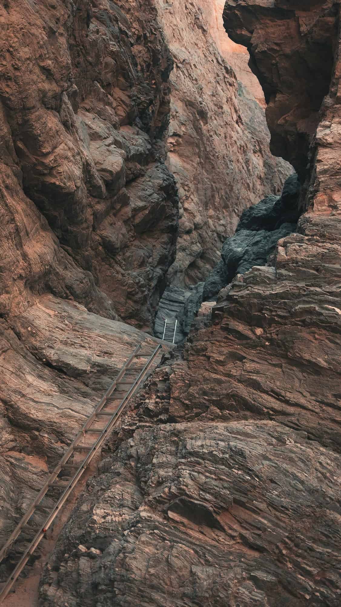
If you like desert slot canyons, you’ll love hiking through Ladder Canyon & Painted Canyon. This trail is not a technical canyoneering route, but you will have to climb up several ladders to make your way through.
After you make it through Ladder Canyon, you’ll be treated to some great views of the area. Then head back through Painted Canyon to see the lovely pink and red quartz juxtaposed against the sandstone.
Pro Tip: 4WD is recommended for the sandy washboard road to reach the trailhead, but some other vehicles might be able to make it. Just watch out for the soft sand where you could get stuck!
8. MURRAY CANYON TRAIL
Murray Canyon Trail Quick Facts:
Type of Trail: Out & back
Total Mileage: 3.7 miles
Total Elevation Gain: 538 feet
Difficulty: Moderate
Another gem of a hike in Indian Canyons, the Murray Canyon Trail leads you to the stunning Seven Sisters Falls. This tiered waterfall splashes into a pool you can swim in to cool off. But try to visit in the cooler months, from October to May, otherwise, the water might be no more than a trickle.
You can also connect to the Coffman Trail on your way back to the trailhead to make a little loop and get a slightly different perspective on the desert scenery.
Note: There is an admission fee of $12/adult to enter Indian Canyons, which you can pay at the trailhead.
9. BUMP & GRIND TRAIL
Bump & Grind Trail Quick Facts:
Type of Trail: Loop
Total Mileage: 4 mile
Total Elevation Gain: 1,102 feet
Difficulty: Moderate
If you’re looking for a leg-burning workout, the Bump & Grind Trail is exactly what you want. It’s a quick way to get some elevation gain in if you’re training for a hike, and it has some lovely views along the way. If you’re lucky, you might even spot some bighorn sheep!
The trail is close to town (the trailhead is right behind the Target in Palm Desert), so don’t expect a secluded backcountry experience – it’s going to be crowded! But for a quick workout and some time on the trail, it can’t be beat.
Pro Tip: Go counter-clockwise to get the steep section done first, and then enjoy the rest of the hike on the way down.
10. CROSS TRAIL
Cross Trail Quick Facts:
Type of Trail: Out & back
Total Mileage: 2.2 miles
Total Elevation Gain: 610 feet
Difficulty: Moderate
The Cross Trail takes you to a local landmark in Palm Desert – a large cross sitting up on a ridge. This hike is quick, but the elevation gain makes it moderately challenging and a good workout. Sunset is a popular time to hike to the cross, which is illuminated at night with an amazing backdrop across the valley.
11. SOUTH LYKKEN TRAIL
South Lykken Trail Quick Facts:
Type of Trail: Point-to-Point
Total Mileage: 4.5 miles
Total Elevation Gain: 1,004 feet
Difficulty: Moderate
The South Lykken Trail provides gorgeous views the whole way along this steep and rocky trail. Wildflowers burst into color here from November through April, and you might even spot bighorn sheep enjoying the trail, too.
Most people do this trail one way (and get a ride back to the trailhead) or walk along the road on the way back for a shorter, flatter hike.
12. MUSEUM TRAIL
Museum Trail Quick Facts:
Type of Trail: Out & back
Total Mileage: 1.5 miles
Total Elevation Gain: 836 feet
Difficulty: Moderate/Hard
This stairmaster of a hike starts behind the Palm Springs Art Museum and heads straight uphill to a fantastic viewpoint. Take in the views, then head back down, and be prepared for some scrambling along the way.
BEST DIFFICULT HIKES IN PALM SPRINGS
13. BEAR CREEK OASIS
Bear Creek Oasis Quick Facts:
Type of Trail: Out & back
Total Mileage: 9.1 miles
Total Elevation Gain: 2,322 feet
Difficulty: Hard
Bear Creek Oasis is a wonderful trail with fantastic views along the way. The hike starts in the sandy desert of La Quinta Cove before heading uphill, and the views of the Coachella Valley, Mount San Jacinto and San Gorgonio, and the Salton Sea get progressively more amazing as you ascend.
But the fan palm oasis tucked in a small canyon at the end of the trail is the real reward on this hike! Spend some time hanging out under the palms before turning around and heading back to the trailhead.
14. MOUNT SAN JACINTO FROM THE TRAMWAY
Mount San Jacinto Quick Facts:
Type of Trail: Out & back
Total Mileage: 10.1 miles
Total Elevation Gain: 2,578 feet
Difficulty: Hard
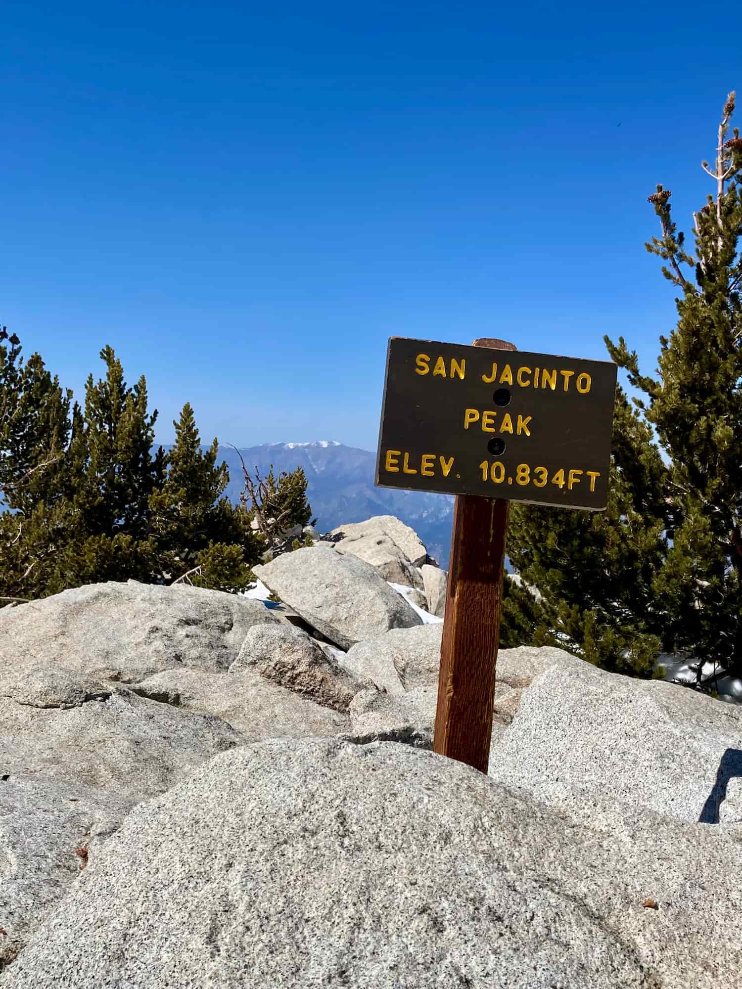
Hiking to the top of Mount San Jacinto from the tramway is such an interesting experience! You’ll start by joining crowds of tourists riding up the Palm Springs Tramway before heading to the ranger station to fill out a permit and enter the backcountry.
Be prepared for the temp to be significantly cooler up here than at the base of the tram, and you may even encounter snow into the spring and early summer. (Our Content Manager Kate experienced some serious Type 2 Fun postholing on this trail in April.)
Once you get out of the woods and head for the summit, you’ll get some great views. And after you make your way back to the tram station, you can enjoy a well-deserved beer and a meal before riding back down.
Note: You must buy a timed ticket for the tramway ($35/person), which you can do ahead of time online here or at the station when you arrive. Tickets are known to sell out, so purchasing ahead of time is recommended.
15. BOO HOFF TRAIL
Boo Hoff Trail Quick Facts:
Type of Trail: Out & back
Total Mileage: 12.8 miles
Total Elevation Gain: 2,290 feet
Difficulty: Hard
This long loop trail in La Quinta showcases the desert and mountainous terrain of this area with views of the Salton Sea, Mount San Jacinto, and Mount San Gorgonio. You’ll also make your way into Devil Canyon and hike around Lake Cahuilla. Boo Hoff Trail is especially beautiful during wildflower season.
Pro Tip: Navigating can be a challenge, and there are lots of forks and side trails, so bring your GPS.
16. ART SMITH TRAIL
Art Smith Trail Quick Facts:
Type of Trail: Out & back
Total Mileage: 16.2 miles
Total Elevation Gain: 3,330 feet
Difficulty: Hard
Immerse yourself in all the desert has to offer on the Art Smith Trail. You’ll feel like you’re deep in the wilderness as you hike through canyons and oases of palm trees, while taking in the breathtaking views of the Coachella Valley. In wildflower season, the blooms explode with color here.
This is a challenging hike, but you can turn around earlier if you want a little less mileage.
17. CACTUS TO CLOUDS (SKYLINE TRAIL)
Cactus to Clouds Quick Facts:
Type of Trail: Point to point
Total Mileage: 20.3 miles
Total Elevation Gain: 10,715 feet
Difficulty: Extremely Challenging
The Cactus to Clouds hike starts from the desert floor in Palm Springs and gains around 10,500 feet of elevation as it heads over 20 miles up to the sub-alpine wilderness and summit of Mount San Jacinto. It has the greatest elevation gain of any trail in the US and is known as one of the hardest day hikes in the country.
But, hey, at least you can take the Palm Springs tram on your way down!
For more details about the Cactus to Clouds hike, check out our guide to the best hikes in Southern California!
PALM SPRINGS HIKING SAFETY
Hikes in Palm Springs range from the desert to the mountains – and some of the hikes have both! Depending on the hike, you will need to be prepared for a variety of safety concerns. Here are some of the biggest hazards when hiking in Palm Springs:
HEAT
The desert environment in Palm Springs can be very harsh with high temps, little shade, and not much water.
Always make sure to bring plenty of water with you, and use electrolytes in your water to replace the sodium lost when you sweat. I typically put electrolytes in my Nalgene and plain water in my hydration bladder. Then I can refill my water bottle from the hydration bladder and add more electrolytes if necessary, but it keeps my hydration bladder easy to clean.
And be sure to bring plenty of sun protection, including sunscreen and sunglasses. It’s also a good idea to familiarize yourself with the symptoms of heat exhaustion and how to treat it before it turns into heat stroke.
SNOW
On the other end of the spectrum, you could encounter snow on the Palm Springs hikes at higher elevation. Be aware that snow can stick around in the mountains into late spring or early summer, so be sure to check conditions and have the proper gear (like microspikes for ice), even if lower elevations are hot and dry.
NAVIGATION
The desert can be extremely disorienting, and while a lot of the trails have decent signage, some trails might not be very well-marked. It’s a good idea to at the very least have a GPS app or even a standalone device, and download GPS tracks to follow for your hike.
WILDLIFE
Rattlesnakes are common in the desert around Palm Springs, and the best way to deal with rattlesnakes is to avoid them. Always check where you’re putting your hands and feet (like under rocks) to make sure a snake isn’t hiding. If you do see a snake, back away or give it a very wide berth to walk around it. Rattlesnakes usually only strike out of protection, so if you leave them alone, they should leave you alone.
Mountain lions can also be found in some of the wilderness areas around Palm Springs, including Mount San Jacinto. While mountain lions typically avoid people, if you do see one, you should never run. Make yourself look big and back away slowly if you can. Avoid bending over, which makes you look more like prey. The National Park Service has more mountain lion safety tips here.
PALM SPRINGS HIKING PACKING LIST
Here are some of the key pieces of gear you’ll want to bring when hiking around Palm Springs, but it is not a comprehensive list. Check out my essential day hiking packing list for everything you should take on a day hike.
*Please note that some of the below links and in this post are affiliate links.
GRAB MY ESSENTIAL HIKING GEAR PACKING LIST
We're making packing for your next hiking adventure easy. Download our essential hiking gear packing list, and you'll always be prepared when you hit the trails!
LOOKING FOR MORE CALIFORNIA ADVENTURES?
For additional California hiking adventures, check out our resources below:
OTHER ESSENTIAL HIKING RESOURCES:
Also, be sure to check out these helpful hiking & backpacking resources!
Have you done any of these awesome Palm Springs hikes? Do you want to try one of these trails? Did we miss any of your favorite hikes in the Palm Springs area? Let us know in the comments below!
Cheers,
Allison - She Dreams of Alpine













27 of the Absolute Best Hikes in Yosemite National Park to Put on Your Hiking Bucket List | Yosemite National Park is one of the most beautiful national parks in the entire United States, and one of the best ways to explore the park is via one the many amazing hiking trails. In this post, I’ve detailed 27 of Yosemite’s top hiking trails, ranging from difficult to easy, that give you epic views of Yosemite’s grand backcountry and some of Yosemite’s most famous landmarks. You’ll only fall more in love with Yosemite after going on one of these hikes! | shedreamsofalpine.com